Skip Navigation
Home
Home
Explore
Explore
Search
Apple macbook pro ear
Sign in
Sign in
Options
Help
Send Feedback
Kjarreilti241
1 year ago
(edited) • 5 views
Report
they expect a marginal on this day according to the forecast discussion which i'll send in the comments
1
0
1
Comments
Kjarreilti241
1 year ago
Report Comment
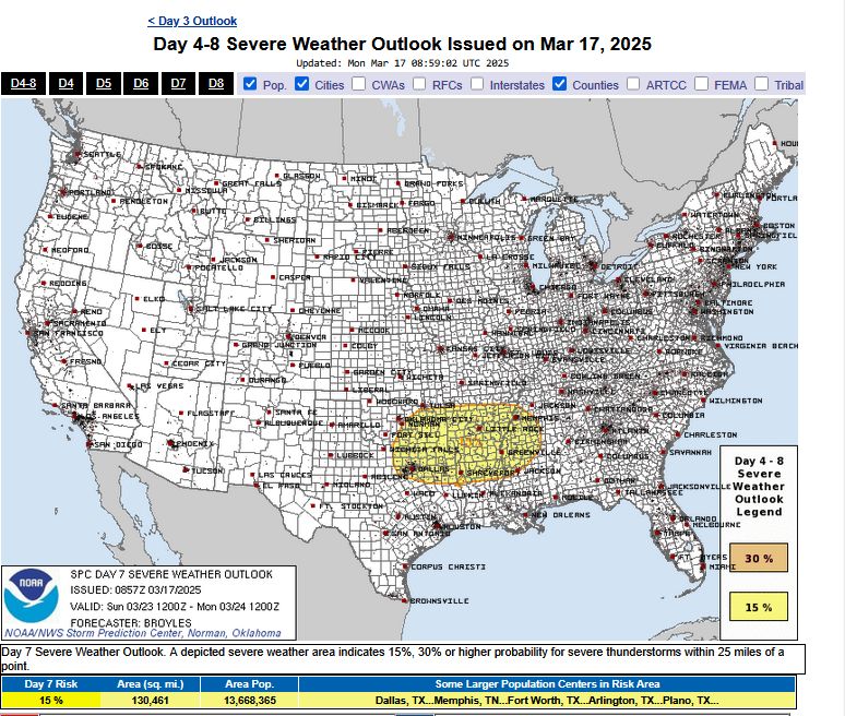
ZCZC SPCSWOD48 ALL
ACUS48 KWNS 170857
SPC AC 170857
Day 4-8 Convective Outlook
NWS Storm Prediction Center Norman OK
0357 AM CDT Mon Mar 17 2025
Valid 201200Z - 251200Z
...DISCUSSION...
...Thursday/Day 4 to Saturday/Day 6...
On Thursday, a trough at mid-levels will move eastward into the
Appalachians, as a cold front advances quickly eastward across the
Atlantic Coastal states. Isolated strong gusts may occur with
convection that develops along or ahead of the front. The threat is
expected to be marginal.
On Saturday and Sunday, a mid-level trough is forecast to quickly
move from the High Plains to the East Coast. A moist airmmass in the
Gulf Coast region is forecast to remain largely in place as the
system passes to the north. This will likely limit any severe
potential.
...Sunday/Day 7 and Monday/Day 8...
From Saturday night into Sunday, moisture advection is forecast to
increase considerably over the southern Plains, as a mid-level
trough moves quickly southeastward across the central U.S.
Medium-range models suggest that the northern edge of the moist
airmass will be located from the Red River Valley eastward into the
lower Mississippi Valley by Sunday afternoon. Thunderstorm
development will be possible along this east-to-west corridor during
the late afternoon and evening, where the models suggest that
moderate instability and strong deep-layer shear will be in place.
Model spread appears low enough to add a 15 percent area, centered
on the Ark-La-Tex for Sunday.
On Monday, the trough is forecast to move eastward across the Ohio
and Tennessee Valleys, as a cold front advances quickly toward the
Atlantic Seaboard. Thunderstorms with an isolated severe threat will
be possible along and near the front during the afternoon, but
predictability is low concerning the timing of the front, and its
associated trough.
..Broyles.. 03/17/2025
0
0
Compose New Post
×
8192
Public
Public
Followers Only
Unlisted
Private
Upload
Add Option
1 day
1 day
2 days
3 days
4 days
5 days
6 days
7 days
8 days
9 days
10 days
11 days
12 days
13 days
14 days
Publish
8192
Upload
Publish

ACUS48 KWNS 170857
SPC AC 170857
Day 4-8 Convective Outlook
NWS Storm Prediction Center Norman OK
0357 AM CDT Mon Mar 17 2025
Valid 201200Z - 251200Z
...DISCUSSION...
...Thursday/Day 4 to Saturday/Day 6...
On Thursday, a trough at mid-levels will move eastward into the
Appalachians, as a cold front advances quickly eastward across the
Atlantic Coastal states. Isolated strong gusts may occur with
convection that develops along or ahead of the front. The threat is
expected to be marginal.
On Saturday and Sunday, a mid-level trough is forecast to quickly
move from the High Plains to the East Coast. A moist airmmass in the
Gulf Coast region is forecast to remain largely in place as the
system passes to the north. This will likely limit any severe
potential.
...Sunday/Day 7 and Monday/Day 8...
From Saturday night into Sunday, moisture advection is forecast to
increase considerably over the southern Plains, as a mid-level
trough moves quickly southeastward across the central U.S.
Medium-range models suggest that the northern edge of the moist
airmass will be located from the Red River Valley eastward into the
lower Mississippi Valley by Sunday afternoon. Thunderstorm
development will be possible along this east-to-west corridor during
the late afternoon and evening, where the models suggest that
moderate instability and strong deep-layer shear will be in place.
Model spread appears low enough to add a 15 percent area, centered
on the Ark-La-Tex for Sunday.
On Monday, the trough is forecast to move eastward across the Ohio
and Tennessee Valleys, as a cold front advances quickly toward the
Atlantic Seaboard. Thunderstorms with an isolated severe threat will
be possible along and near the front during the afternoon, but
predictability is low concerning the timing of the front, and its
associated trough.
..Broyles.. 03/17/2025